Rod Hunt is a London, UK based map illustrator specialising in detailed isometric map illustration and plans for school campuses, theme parks, events, parks and cities.
Style, Approach and Uses of Illustrated Maps
With 30 years experience as an illustrated map designer he’s created maps for clients worldwide including schools, universities, sporting events, theme parks, tourism brands and more. His love of detailed map illustration was fuelled by theme park and tourist attraction maps from his childhood. Rod's own maps are usually very detailed adding layers of humour and interest often populated with little characters and easter eggs to entertain the viewers as well as inform. Clarity of navigation is essential ahead of the detail, the London Underground Map is great example of distilling a map down to its essential elements by simplifying the geography, it’s often on Rod's mind when working on a visual approach for a new map project.
In this article Rod showcases his various styles and ways of executing an illustrated map suitable for a client's needs. What do you need from an illustrated or pictorial map, is it ease of use as a navigational tool with geographic accuracy, exciting marketing images or a mixture of both? A simpler graphic map or levels of detail and complexity? It's important to understand how the map will be used when briefing a map illustrator to ensure it meets the requirements of its users.

Illustrated Theme Park and Tourist Attraction Maps
Creating a fun and engaging map for your theme park or tourist attraction is very important as it gives it excitement beyond a functional navigational tool becoming a key marketing promotion to instil excitement to potential visitors.
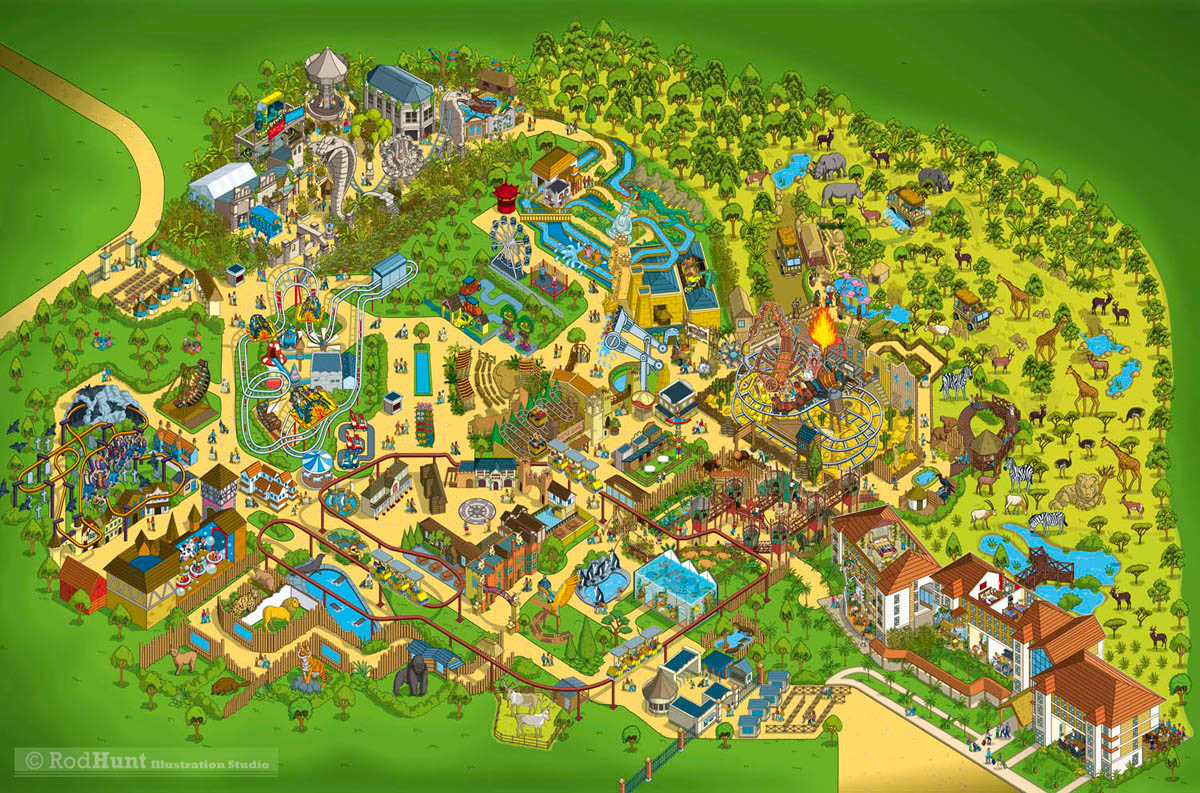
Rod Hunt illustrated the Visitors Map for Chessington World of Adventures Theme Park. The key aims were to simplify the complex layout of the park to create an accurate and easy navigation tool for visitors, to be colourful, fun and appealing to the target family audience and to be easily updatable for the inclusion of future rides and attractions. The rides and attractions were illustrated in a fun and detailed way playing with scale while keeping a level of accurate depiction.
Illustrated Property Development Maps
Rod was commissioned to visualise the different phases of a new properly development for an advertising campaign for Bhartiya City outside Bangalore, India. The property development required a detailed 3D illustrated map using isometric perspective as a key visual to promote the development to potential residents and businesses. Rod worked from a huge amount of architectural drawings of the buildings, 3D renders and site plans of the upcoming phases to create a playful, colourful, green and vibrant place to live and work. Another more architectural approach can be seen in his Battersea Power Station Development Map which gives a neighbourhood overview of the current and upcoming phases of the multi-billion Pound development in London that surrounds Battersea Power Station.
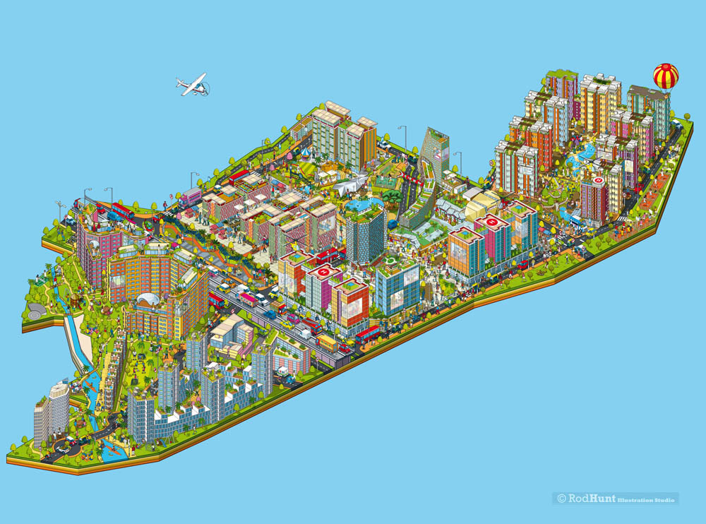
Bhartiya City Isometric property development map illustration used for a major advertising campaign
Illustrated Campus Maps and Site Plans for Schools, Colleges and Universities
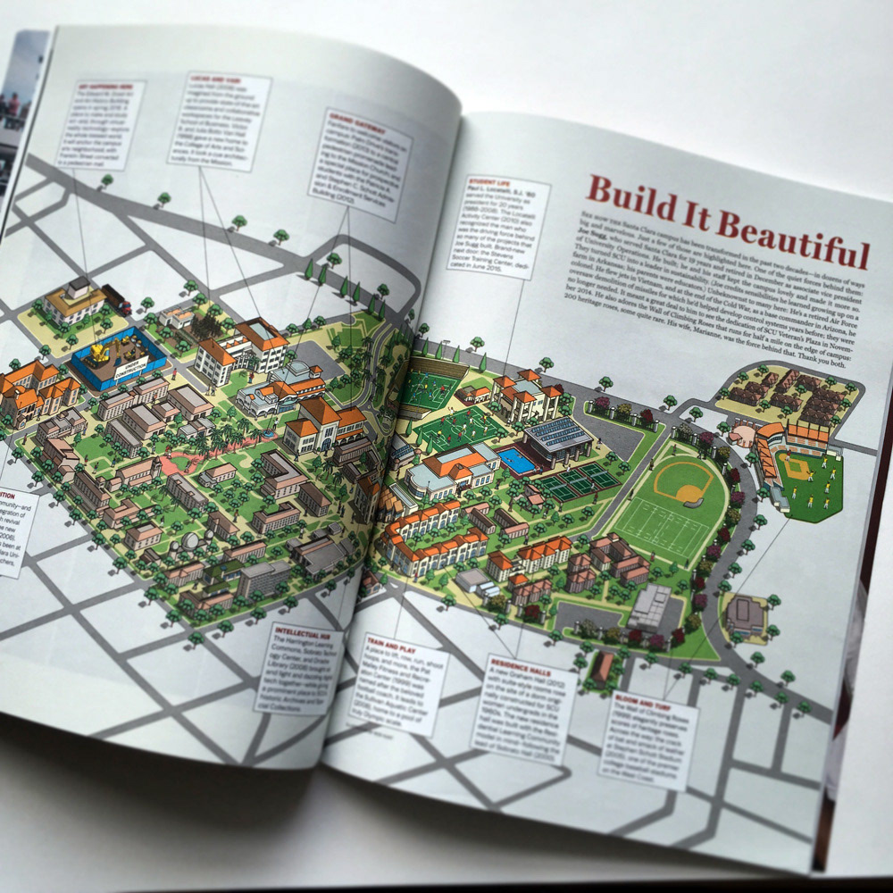
Schools, colleges and universities can have various needs from an illustrated map or plan, a navigational tool, overview of the campus buildings or a key showcase of facilities. With Rod's illustrated campus site map for Santa Clara University the aim was to highlight some of the significant ways that the campus was transformed with new buildings and facilities built over the last two decades. A simper approach was chosen to depict the campus with a more graphic and simplified style.
Rod's Cheltenham College Prep School Campus Map took a different route with more detail and exaggerated depictions of the buildings and cutaway's to show interiors. There was also an added layer of Where's Waldo / Wally? style search and find for extra interest and excitement. The map illustration was used as a key marketing tool and an interactive page on the schools website to showcase the superb facilities of the school.
Detailed City Map Illustration
Rod Hunt was commissioned to create a detailed and expansive illustrated city map of the historic city of Jodhpur for The JDH, an Urban Regeneration Project that aims to restore the Walled City of Jodhpur to its former glory, breathing new life into its invaluable landmarks and livelihoods. The illustrated map of this ancient city needed to capture a sense of fantasy and magical reality that included Jodhpur's key landmarks and monuments, main street routes as well as elements of Jodhpur's rich culture, architecture and landscape.
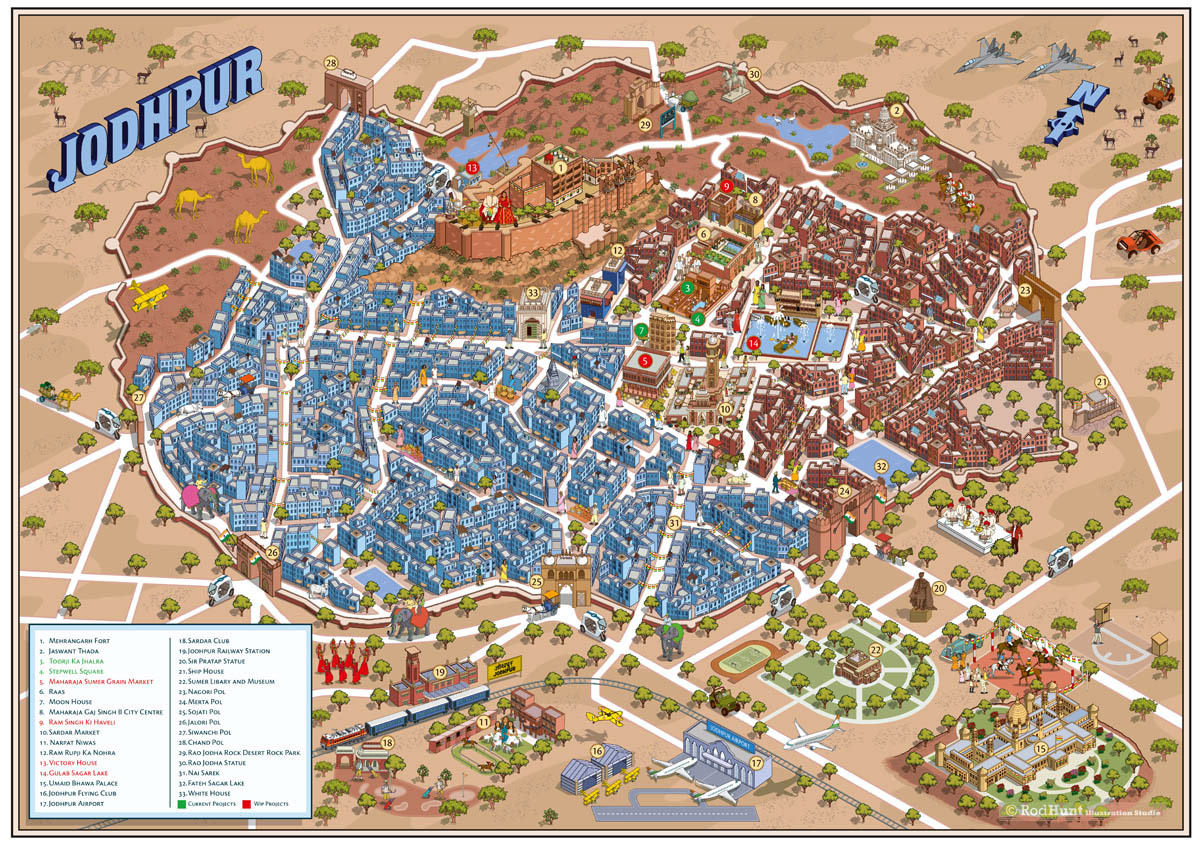
Detailed and expansive city map illustration of the historic city of Jodhpur
Illustrated Tourist Maps of Landmarks
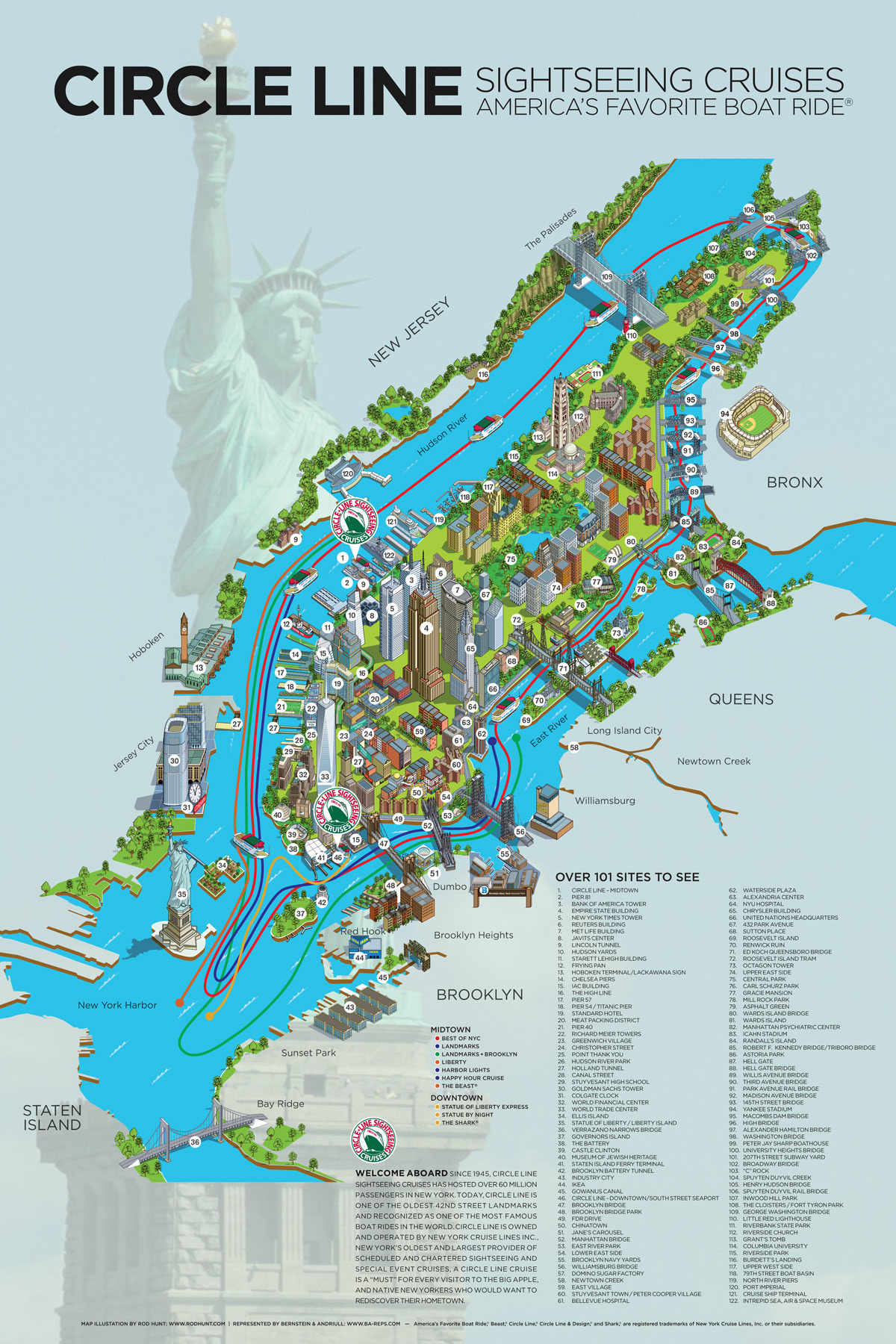
Another approach is a mixture of a simpler graphic background with highly rendered accurate illustrations of buildings and landmarks like in Rod's illustrated map of 101 sites in New York for Circle Line Sightseeing Cruises. Their aim was to show the different landmarks, buildings, monuments, neighbourhoods and attractions a customer can see from their various New York cruise routes around Manhattan. Here he creates an overview of landmarks in New York with less emphasis on the maps use as a navigational tool. Highly rendered buildings and landmarks feature in the approximate location with simpler graphic background, playing with scale to enhance impact and clarity.
Sports and Entertainment Event Maps
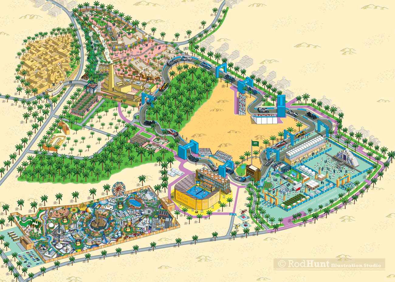
The Saudi Arabian e-prix and event map needed to convey the overall site the sporting event for use as a navigational tool and marketing tool. The brief was to create a fun, detailed and engaging 'Disneyland' style theme park map illustration showing the race circuit, wider festival site, hospitality and facilities on offer across the three days of the Formula E event with live music from international artists, entertainment, cultural activities and gripping city street racing. A mixture of clear routes for navigation was mixed with detailed depictions of the site features.
A more focused approach was required for Time Out's 50th Birthday Party Event Map Illustration, a one night event at a small intimate site in Granary Square King's Cross. Rod went into great detail for each of the areas, including live music stages, comedy stage, hospitality and facilities to care an exciting overview of the event. The map illustration was used as a key marketing tool in the run up to the night.
Building Cutaway and Exploded View Maps
Print company 1st Byte wanted to create an exploded view building virtual tour map to show customers the company's extensive print and finishing facilities. Rod illustrated an exploded cutaway building illustration that showed the company at work. The image was used an an interactive tour showing each floor in detail with key printing machinery shown in detail.

Illustrated Event Maps for Trade Shows and Exhibitions
Rod Hunt created a detailed and fun exhibition and event map illustration for the Top Gear Live show at Excel London, in the style of his bestselling Top Gear Where's Stig? search and find book. The map needed to show the indoor racing track, Live Action Arena plus a recreation of the Top Gear studio, special tributes to Top Gear's greatest challenges and some of the more creative and famous machinery from the TV show. The illustration was used as a key marketing image to promote the event.

If you're looking to commission a map illustration please feel free to contact Rod to discuss your requirements.
View Illustration Portfolios: Illustration - Map Illustration - Search and Find Illustration - Where's Waldo / Wally Style Illustration - Book Illustration
Infographic Illustration - Animation - Isometric Illustration - Isometric Art - Cutaway and Cross Section Illustration - Advertising Illustration